The term El Niño first appeared in the English language at the end of the nineteenth century—and not so much because of the fishermen’s melancholia, but as a name for the change in the current in the waters below. What happened was that the cold waters of the Humboldt Current, part of the normal pattern of Pacific circulation that powerfully sweeps Antarctic waters northward up along the South American coast before the waters head west along the equator, become on occasion mysteriously disrupted. Instead they are replaced, or nudged farther out to sea, by an irruption of warm water that bullies its way down from the equator—and in the case of the anchoveta, this warm water smothered the upwelling of nutrients on which the little fish fed. The fish then went elsewhere, well beyond the ken of the Peruvian fishermen. They simply vanished from Peru.
Early on it was nothing more than the change of current, this unusual warming of the sea, that came to be named El Niño—and it remained so until oceanographers and climatologists in the mid-twentieth century realized that the change of currents off Peru was just one of many features of a much larger and more important phenomenon, one that had its impact across the entire breadth of the ocean.
Many names are associated with the research that confirmed this. One in particular belongs to a civil servant in British India, Gilbert Walker, who had a meteorological epiphany in 1924 that helped secure what would become the Pacific’s reputation as weather maker for the world.
Sir Gilbert Walker, described in the closing paragraph of his 1958 obituary as “modest, kindly, liberal-minded, wide of interest and a very perfect gentleman,” was a classic of his breed, a polymath of the old school. He was first and foremost a Cambridge mathematician—no less than the 1889 Senior Wrangler, meaning that he had achieved his country’s greatest intellectual achievement of the year. But he was many other things besides: a designer of flutes, a keen student of the boomerang and of the flight paths of ancient Celtic spears, an authority on the aerodynamics of birds’ wings, a passionate advocate of the sports of skating and gliding, a wizard in the more arcane uses of statistics, and a recognized expert on the formation of clouds.
He loved India and the Himalayas, and when he was appointed director-general of observatories in India, he spent twenty years trying (in vain, as it happened) to figure out a mathematical means of predicting monsoons. He had been led to this obsession by a monsoon failure in 1890 that caused a terrible famine. His frustrated quest might well have caused him to leave India somewhat deflated—except that, as it happened, Walker’s work on the monsoon prompted him, during his retirement years, to come up with quite another and rather more globally significant discovery.
He was a habitual collector of what turned out to be colossal tonnages of meteorological statistics. His exhaustive analysis of these, of decades of weather records from all across the British Empire, allowed him to demonstrate incontrovertibly that the El Niño events occurring off the Peruvian coast—the fishermen’s phenomenon was by now well known to scientists around the world—were part of an enormous and all-encompassing transpacific set of weather patterns. These patterns turned out to be mirror-image combinations, in which precisely opposite meteorological manifestations were occurring on one side of the ocean or the other, in one season or another, for one extended period or another.
Periods of warming here led to episodes of cooling there. The Peruvian sea starvation during a locally warm-sea El Niño event would in time be followed by a local sea cooling and return to abundance, and that would be called (keeping to the Christmas-themed naming practice) a La Niña time. Floods on one side of the ocean led to droughts on the other. There were periodic swings in weather and in the human response to it. There were times when there were more cyclones and times when there were fewer. Some years when the Indian monsoon never happened, the fields were parched and crops failed. Other years were marked by luxuriant summertime drenchings. There were years of famine and years of abundance, of dust bowl summers and harvest-rich autumns, years of concomitant prosperity and ruin, periods of consequent peace and turmoil—within the Pacific, around the Pacific’s coasts, and even, perhaps, beyond them and around the globe.
And all of it—Sir Gilbert Thomas “Boomerang” Walker realized through all his Renaissance man amusements of flutes and bird flight and skating techniques—was due to a hitherto unseen natural phenomenon. Walker declared that what drove the regular and dramatic changes in the Pacific weather must be some kind of repeating mechanism high up in the atmosphere. Whatever it was, this pattern of invisible winds and movements seemed to him to operate as a kind of unseen atmospheric seesaw, a beam engine balance around a central pivot lying somewhere smack dab in the center of the ocean.
The axis seemed to hover where the International Date Line crossed the equator, in the middle of that sprawl of limestone specks then known as the Gilbert Islands and the Phoenix Islands, now the Republic of Kiribati. Up on one side of this fulcrum meant down on the other; high pressure here meant low pressure there; hot here, cool across the other side; cruelly wet in this place, bone dry in that. It had a beautiful logic to it; and measurements taken over the years that followed have proved that Walker was exactly right.
This transpacific atmospheric wind pattern he discovered was in time to be named, and in his honor, the Walker circulation. This was the engine, the mechanism, that then produced what Sir Gilbert himself went on to name, for the back-and-forth, hot-and-cold, wet-and-dry, stormy-and-serene periods that appeared to dominate the tropical Pacific’s weather: the Southern Oscillation.
ENSO—the acronym is formed from the combined initials of the El Niño and the Southern Oscillation—denotes what today is recognized as undeniably the planet’s most important climatic phenomenon. If the Pacific is truly the generator of the world’s weather, then ENSO represents the turbines that give it the power to do so. And the Walker circulation is the force that sets the turbines spinning in the first place.
The Walker circulation’s basic structure is made up of long-lasting cells of pressure in certain places around the ocean. The eastern Pacific generally has high atmospheric pressure. Correspondingly, the western Pacific generally has a large low-pressure area, most notably around the sea-spattered islands of Indonesia and the Philippines, the area that oceanographers and meteorologists like to call, if oxymoronically, the Maritime Continent. The air above the ocean then moves, as physics demands, from the high-pressure area to the low—in other words, from east to west. The trade winds at the surface, which blow nearly constantly in this direction, are of course this movement’s very visible and familiar manifestation.
As the winds blow in this manner, they help push the warm waters of the tropical seas below them in the same direction. Incredible though this may sound, the sea then piles up very slowly and deliberately as a huge wave of water passes steadily across and into the western reaches of the ocean. The western Pacific can sometimes be a full two feet higher than the waters in the east. Some of this warm water evaporates as the huge cyclonic storms and typhoons, such as Tracy and Haiyan, form over the western seas. Some of it dives deep back into the ocean, cools, and is returned to the east by the work of deep ocean currents. In a normal series of years, this pattern is repeated again and again: the Walker circulation of the air above, the migration of the seawater below, the explosive growth of storms in the far western Pacific, the return of the cool and dry air and upwelling cool water (and with them the anchovies) to the Pacific east. As a result, calm and stability reign.
But sometimes, and for some still unexplained reason, the Walker circulation changes. The trade winds weaken or falter or even reverse their direction, and then an El Niño period occurs, and the system changes with it, and dramatically. It can sometimes strengthen in the opposite manner and with equal drama—and then the reverse, the phenomenon of La Niña, dominates the weather picture instead. Tracking and measuring the arrival of the two phenomena, El Niño and La Niña, have lately become major elements in worldwide weather forecasting and climate modeling. It is safe and reasonable to say that in the computation of the planet’s weather, all eyes are on the happenings in the Pacific and the behavior of the Southern Oscillations. For as the Pacific oscillates, so oscillates the world.
These days the Southern Oscillation that Gilbert Walker defined is measured by the careful tracking of the atmospheric pressures and the sea temperatures in the region. Pressure is measured at two key points: one in Tahiti, the other down in Darwin. If the pressure in Tahiti falls significantly below what is normal, and at the same time the pressure in Darwin rises above what is normal, then an El Niño period is declared to be under way. The American and the British weather services also like to measure sea temperature along the narrow equatorial zone that is (in more ways than one) central to the development of an El Niño. If the water temperature in the eastern part of this region (that closest to the South American coastline) rises by half a degree Celsius, and if, in accordance with the British weather researchers’ rules, it then holds that temperature for nine full months, then an El Niño is declared to be under way.
The Japanese government in particular is investing millions in its own studies of El Niño, and for good reason. Japan has historically been a magnet for highly destructive Pacific typhoons, storms that, along with the earthquakes, tsunamis, and volcanic eruptions that bring regular ruin, have helped forge the national character traits of stoicism and mutual philanthropy. Forecasting such traumatic occurrences would of course be a fine thing, for the national economy, for the nation’s morale. The recent accelerating ability to forecast the eruptions of volcanoes may still not have been matched by an ability to predict earthquakes. But to balance that, a major effort is now being made in Japan to fine-tune global long-term weather forecasting, and in particular to investigate the possibilities of predicting when an El Niño—with its clustering of typhoons—is most likely to occur.
This task is being handled by what has been claimed variously to be one of the world’s largest, most powerful, fastest, and most efficient supercomputers. It is grandly known as the Earth Simulator 2, and it is sited in a suburb of Yokohama, west of Tokyo, in the offices of JAMSTEC, the Japan Agency for Marine-Earth Science and Technology.
As a record breaker, the Simulator has recently been knocked off its perch by a new superfast machine in China, but it is still a remarkable and home-built device, which keeps being improved and upgraded: currently it can calculate at the rate of 122 teraFLOPS (122 trillion floating-point operations per second). A recent live test—which was conducted in its building with no more than the usual electrical hummings and air-conditioning whirs and the flashing of thousands of light-emitting diodes, and with only the operators squinting rather tensely at their terminals hinting at any anxiety—showed that the contraption can produce global weather analyses of witheringly complex detail: several times a day it can produce a three-dimensional map of the world’s atmosphere, showing the climatic details every three miles horizontally and through more than one hundred slices of the atmosphere vertically.
It is so costly a creation, and Japan is so seismically unstable an island chain, that its guardians protect it as if it were the Mona Lisa or the Hope Diamond. It has its own building mounted on gimbals and rubber feet; metal-mesh ceiling nets to diffuse lightning strikes; and special metal shields to keep stray magnetic fields at bay.
Swaddled in care, Japan’s Earth Simulator quietly crunches away at the numbers of what it sees. Its operators continue to try to divine, as do many others in similar laboratories around the world, whether the onset of an El Niño or a La Niña can be declared not merely under way but about to happen. Can it be predicted, in other words, just like any other weather forecast?
Most recently the Japanese team working on El Niño has been able to show that the onset of an ENSO warm phase is often preceded by a machine-gun-like series of small and intense storms north of Australia, in the waters off Papua New Guinea. The storms are small enough to be known as westerly wind bursts; and though for a while they were dismissed as random events, unconnected to the happenings on the far side of the ocean, nowadays scientists believe they may be linked. But as to whether they indicate the onset of an El Niño, or whether they are the result of the onset of an El Niño, is a matter of much debate in the meteorological community.
No one yet has come up with a way to forecast the onset of ENSO—which is a major concern at a time when the worldwide weather has become such a worldwide obsession. For .
Locally, their effects have been noticed for centuries. The first is familiar, but it bears repeating: the inflow of warm water in the eastern Pacific halts the cold upwelling rush of nutrients; all the anchovetas vanish from the waters off Peru; other sea creatures die; noxious gases from rotting marine carrion bubble up from the sea; boats have their paint blistered by the scum of acidity.
Globally, a host of other phenomena can develop in tandem, all probable knock-on effects of these particular changes in this, the world’s biggest expanse of seawater. The expanse, it is worth restating also, of heat-catching seawater—for the catching of solar heat is ultimately what this meteorological drama is all about.
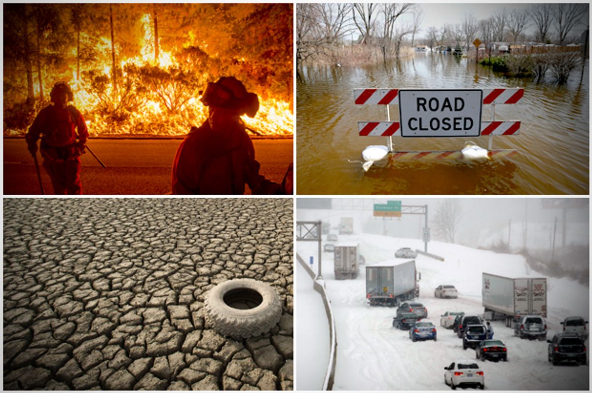
So during an El Niño there can be, among other things, major flooding on the South American west coast (with the current-warmed humid breezes rising above the Andes, the humidity condensed and then precipitated out as rain or snow). During this phase, there can be droughts in northern Brazil, but severe rainstorms near Rio. Cyclones and typhoons tend to form in the Pacific more centrally than usual during an ENSO warm phase, and since the storms spend longer times tracking their way westward over larger expanses of warmer seas, they can grow and accelerate and deepen, and thus can be much more violently destructive when they finally reach land.
The 1982–83 El Niño, one of the strongest ever known, was memorable for its cascade of events. The trade winds weakened. Sea levels in the eastern Pacific began to rise (up to a foot higher along the coast of Ecuador). Eastern sea temperatures shot up. Fur seals and sea lions began to die off the coast of Peru. Deserts in eastern South America were drenched with rain, grasshoppers swarmed, toad populations went through the roof, mosquitoes came in clouds, and malaria cases skyrocketed. There were droughts and forest fires in Java, terrible storms wracked the coastline of California, there was flooding in the American Deep South, ski resorts in the American Northeast reported warmer weather and lackluster business. All told, the economic cost of the 1983 El Niño was estimated by the U.S. government at eight billion dollars—and of course for every malaria-related death in Ecuador or for every village burning in Sulawesi, boundless misery.
That was an extreme event. Even during a modest El Niño the effects can be widespread and unexpected. Drought can affect Hawaii, drastically lowering the sugar crop (and before 2009, when Dole pulled its business out, the pineapple crop, too). Forest fires can and do sweep across Borneo; monsoon-dependent crops can wither and fail in India. Sea lions and elephant seals die in the waters off California; unanticipated fish and squid appear in the waters off Oregon and British Columbia. A supposedly moderate El Niño in 1877 triggered a two-year drought in China and the deaths of nine million people from starvation. The polar jet stream can be nudged farther southward during an El Niño event, making winters in Canada more acutely cold, forcing more rain to fall in the southern states, cooling everything down—and shortening the growing season for Florida oranges. Northern Europe is colder and drier, Kenya wetter, Botswana drier. The effects are legion, the lists endless (and at times, seemingly contradictory), the concerns global.
And the matter of global warming is a constant concern, underpinning or overlaying everything. The differing scales of the events involved are irksome to those employing statistics to help spot trends and links. The wildly complex mechanics of an El Niño oscillation occur over fairly short intervals, for instance. The best-known parts of that equation, the Walker circulation and the ENSO, operate at fairly short intervals, in three-or four-or five-year cycles.
It can become very much more complicated than this. Yet other, more arcane atmospheric and oceanic phenomena—such as the Kelvin waves and Rossby waves that move quantities of ocean hither and yon around the subsea boundary between warm and chill waters known as the thermocline—are similarly swift in their operation. As are the so-called Hadley cells and their more northerly cousins, the Ferrel cells, which operate in the atmosphere rather than the sea, and which bring much rain, and swirl about under the majestic impress of that westward and world-dominating force which was discovered in Victorian times by the Frenchman Gustave-Gaspard Coriolis, and which bears his name today.
All these named phenomena operate in relatively rapid, time-lapse motions. As does a final main, named component of the entire Pacific process, and perhaps the fastest of them all: it is known as the Madden-Julian Oscillation. This is best described as a traveling wave of unusual atmospheric behavior. When functioning as normal, it brings periods of hot storms and blustery rains to the tropical western Pacific, and it does so every thirty to sixty days.
Global warming, though, operates with very much more languor than this. Most mathematical models suggest that the central tropical Pacific will not rise in temperature by three degrees Celsius until the end of the twenty-first century. At the same time, the level of the sea will have risen between one and three feet, according to the Intergovernmental Panel on Climate Change. How will those two long-term changes affect, or else be affected by, the El Niño warm phases expected during the remaining decades of the century? It would be at least convenient to know this, because the world’s weather is entirely born of this phenomenon, and substantial changes like these either are caused by it or are the cause of it.
Little is certain, though the computers hum. One recent observation that has produced consistent enough results to be called a discovery is that the Walker circulation, Sir Gilbert’s lasting legacy, has steadily weakened over the last sixty years. Moreover, it has done so, with weakening trade winds its most obvious demonstration, at a rate that is entirely consistent with the rising temperature of the Pacific’s surface. And as will be re- called, a weaker Walker circulation is linked with the start of an El Niño warm phase—which suggests, to put it most crudely, that if this trend persists, the world could find itself in a state of more or less permanent El Niño conditions.
And that, with its corollary of ever more extreme weather events in the western Pacific and over the North American continent (to say nothing of a total permanent collapse of the Peruvian fishmeal industry), could cause long-term changes to human behavior, to the siting of cities, to the planting of crops. But little is certain. Thanks to the new computers, and to the fascination with Pacific weather, global forecasting is less of a crapshoot than once it was. But out in the Pacific it remains a mystery of daunting complexity.
* * *
Yet a consensus of a sort appears to be building. It is all to do with heat, with the radiation from the sun, and with the manner in which the planet deals with it. Not a few climatologists are coming now to believe that because of its immense appetite for absorbing the solar heat, the Pacific could in time actually be seen as the savior of the world’s living creatures. It will be so by taking in all that destructive heat from the sun and from the excesses of carbon emissions and, rather than allow it to scorch dead the inhabited earth, employ it to warm itself up, slowly and sedately, as befits the dominant entity on the planet, and thereby enable itself to carry the world’s heat burden on its own.
The effects of all that absorption of warmth will be locally dramatic, for sure. As the American admiral fretted, there will be bigger and more destructive typhoons; there will be more super Tracys, more stupendous Haiyans. There will perhaps be a more urgent need to evacuate islands that will be inundated more swiftly than was thought. Maybe there will be bigger snowfalls in the Cascades and the Sierra. Maybe no anchovies will ever be caught again off Peru. Maybe the forests of Sarawak will be consumed by fire.
Locally, there will be mayhem. But globally, less so. The planet, perhaps, will manage to heal itself. The world and its creatures will survive, and all will eventually allow itself to come back into balance, just as the geologic record shows that it survived and returned to balance after any number of previous cycles of excess and danger. And once that happens, the Pacific Ocean will be seen, uniquely, for what many climatologists are coming to believe it to be: a gigantic safety valve, essential to the future of the planet
The ocean’s monstrous size puts it in a position to let the planet go thermally wild for a time, to wobble dangerously. But then, like a formidable gyroscope, the Pacific will dampen the excess, will help bring sanity back, and will restore calm, serenity, and normality.
The Pacific Ocean as the world’s pacifier—the thought is maybe born of all too little science. But it is a thought endowed with poetry, and is now held by many. And in the gloom-dimmed world of today, even such a thought is surely a most welcome one.
Excerpted from "PACIFIC" by Simon Winchester. Copyright © 2015 by Simon Winchester. Reprinted courtesy of Harper, an imprint of HarperCollins Publishers.
Shares