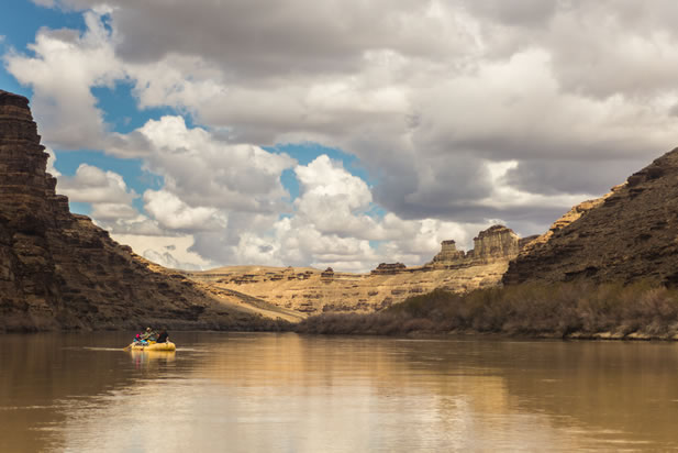
On a chilly morning in April, our group of six pushes out from Sand Wash into the slow, silt-laden current of Utah’s Green River. Our guides, environmentalist John Weisheit, and his wife, Suzette, have traveled this way dozens, perhaps hundreds of times. They lost count a long time ago. The other members of the crew include Moab conservationist and river guide Laurel Hagen, biologist Joseph Leyda, photographer Jonathan Byers, and me. Our destination lay in the drab distance ahead – the great rock labyrinths of Desolation Canyon, one of the West’s last great wild places, and also one of its most threatened.
Two well-worn rafts, red and yellow, make up our flotilla. They are piled high with gear, water, and fuel, enough for eight days in the backcountry. The red one, John’s boat, is sun-faded and sandblasted, emblazoned with the logo “Colorado Riverkeeper.” The yellow one is Suzette’s. At the end of a small string tied to her boat is a rubber duck bath toy, which over the years has been dragged, ass over quacker, through countless rapids.
After a final gear check, we pull the rafts from shore and into the current. The red boat in which I’m riding lurches to a stop on a rock just below the surface. To free it, we hop into the achingly cold water, grab hold of the webbing strung along the raft’s edge, and heave upward. After a few tugs we manage to ease the raft from its high-center and begin our slow, 80-mile crawl into the heart of Desolation.
The colorful boats clash with the ashen sky and the gray marls and shale of the canyon walls and the gray-green water, which offers no reflection. Belted kingfishers perch in the leafless cottonwoods and alders, giving a rattling snicker before they careen from the trees and skim over the water’s surface.
It’s not difficult to imagine this canyon as it was when John Wesley Powell, Desolation’s first chronicler, passed through in a wooden dory in 1869. In his account of his journey, he described the canyon as “a vast labyrinth of canyons, cliffs, buttes, pinnacles, minarets, and detached rocks of Cyclopean magnitude, the whole destitute of soil and vegetation, colored in many brilliant tones and tints, and carved in many weird forms.” Although he didn’t know it at the time, Powell would bestow on the canyon its name when he declared it “a land of desolation, dedicated forever to the geologist and the artist, where civilization can find no resting-place.”
Desolation – or simply “Deso” to those who know it well – is also a place of geological superlatives. The uplands are high, reaching an elevation of almost 10,000 feet, supporting fir and spruce. From the rim the gorge steps down in wide terraces to the river bottom. In its deepest reaches, the gorge is about 5,500 feet from rim to river, a greater vertical relief than the Grand Canyon. Yet Deso gets only a fraction of the traffic as the iconic canyon to the south. Those who do come typically confine themselves to a narrow band beside the river, rarely venturing into its labyrinths of side canyons.
Like the Grand Canyon, Desolation is cut into the multilayered sediments of the Colorado Plateau, the vast red rock uplift formed in the tectonic collision that created the Rockies. The sandstones, shales, and limestones are among the youngest layers in the Colorado Plateau, from a mere two million to about 150 million years old. (By comparison, the schist and gneiss at the bottom of the Grand Canyon are among the oldest on Earth at roughly two billion years old.) In her chronicle of Desolation, Raven’s Exile, guide and writer Ellen Meloy wrote of the geological descent through Desolation and adjacent Gray Canyon, “You launch in mammals and end up in sharks and oysters.”
Today, Desolation and its surroundings, like vast swaths of the West, are in an epoch defined by the skeletal frames of gas and oil rigs. In many places, this industrial front has pushed to the margins of the US’ national parks and wilderness areas. A 2012 report from the Center for American Progressfound that 42 parks across the country were under threat from gas and oil development. Perhaps none illustrate that siege better than Teddy Roosevelt National Park, in North Dakota, where energy development has rapidly encroached on the park’s boundaries. Today, several oil wells are visible from the Elkhorn Ranch, the so-called “Walden of the West,” Roosevelt’s homestead, where, before his presidency, he meditated on the value of wilderness and developed many of the foundational principles of the National Park system.
For now, at least, the borders of our national parks and wilderness areas are still sacrosanct. But areas like Desolation – places of outstanding wilderness character without the benefit of federal wilderness designation – are extremely vulnerable. Desolation, I’ll come to learn, is one of the new battlegrounds in the contest between wildlands conservation and resource extraction.
“It’s one of the largest roadless areas in the lower 48. It’s valued for its scenic beauty, its wildlife, its cultural resources,” says Nada Culver, a spokesperson for the Wilderness Society. “Places like these have huge value aside from the profits that can be extracted from their natural resources.”
The inner gorge of Desolation Canyon is designated as a “wilderness study area,” but its surroundings are a patchwork of private, state, tribal, and federal lands sandwiched between Utah’s largest oil and gas-producing regions – the Uintah Basin to the north and Cisco Desert to the south. Desolation Canyon cuts into the Green River Formation, a deep layer of sedimentary rock straddling the borders of Utah, Wyoming, and Colorado. Formed between 33 and 56 million years ago, when a vast lake covered the region, the Green River Formation is scattered with petroleum sources. A recent US Geological Survey report states that the formation holds as much as 1.3 trillion barrels of oil. By comparison, the Bakken Formation in North Dakota, where the nation’s fiercest oil rush is underway, holds about 30 billion barrels.
Drawn to the whiff of hydrocarbons like vultures to decaying flesh, energy companies are rapidly closing in around the wild plateaus and the canyon itself. With the advent of hydraulic fracturing, the number of gas and oil wells drilled annually in the surrounding areas has increased tenfold since 1989. But there’s a catch. What’s found here in great quantities is not oil, but two unconventional fossil fuel sources – tar sands and oil shale – both of which must be strip-mined and subjected to energy- and water-intensive processing before they yield the oil trapped within.
Hanging in the balance of this energy equation are not merely enormous tracts of wild lands, but the strained-to-breaking water supplies of the Colorado River system, which provides some 40 million people in seven states with drinking and irrigation water.
On our first day, the river runs before us smooth and silent. The boats glide between sandbars, past long tamarisk-covered islands that split the channel in two. Weisheit steadily pulls at the wooden handles, leaning back. The plunge of the paddles is rhythmic – a measured whoosh as the paddle breaks the surface, followed by a loud cascade that fades to a slow drip before the paddle plunges into the water once more.
Weisheit wears a ball cap pulled low over his sad eyes and slightly bulbous nose. His calm face often betrays his deep concern for this river, his river, as he’s come to think of it. His concern often turns to outright indignation as he rails against the West’s “water buffaloes,” the powerful water authorities responsible for shuttling tens of billions of gallons of Colorado River across the dry landscape, via vast canals and aqueducts, to spur the construction of golf courses, strip malls, and tracts of McMansions. In protest of these egregious patterns of water use in the arid West, Weisheit wants to launch his raft in the eight-acre “dancing water” fountain at the Bellagio Casino in Las Vegas. “That fountain is technically part of the river,” he says. He’s even emblazoned his camp toilets with the names Floyd Dominy (the hated former Bureau of Reclamation commissioner) and Ted Hatch (a rival river guide who ran motorized boats through the Grand Canyon). “Anyone else need to use the Dominy?” he likes to ask in his characteristic deadpan before stalking off into the juniper, toilet paper in hand.
Today, Weisheit’s shoulders are sore, as they are on most mornings – the bodily wages of three decades as a river guide combined with the more recent atrophy of pecking at a laptop, filing press releases, or digging for documents detailing the long-running siege on Utah’s public lands. The easy rowing of the upper canyon is good for them, he says, tucking the oars under his armpits, letting the boat pirouette slowly in the current, rubbing his left shoulder with a calloused right hand that could just as easily belong to a boxer.
Weisheit is a throwback Western environmentalist, an iconoclast who leads from the backcountry. Though his main cause – the removal of Glen Canyon Dam – has largely been abandoned as too radical by most environmental groups, he presses on. He recounts visiting Glen Canyon as a child, a few years after the floodwaters began to rise. He remembers gliding in a boat by an inundated side canyon, one that he had visited a year or two earlier and found filled with petroglyphs and Anasazi ruins.
Another defining moment came when he met legendary environmentalist David Brower at a meeting in Berkeley in the mid-90s. At Brower’s urging, Weisheit organized a Sierra Club group in 1999 that lobbied for Glen Canyon Dam’s decommissioning. A year later, he started his own organization, called Glen Canyon Action Network, which, in 2002, was renamed Living Rivers. “I didn’t know Brower long,” Weisheit says. “But I’ll never forget the most important thing he told me. He said, ‘You have the best voice for the Colorado River because you’re out on it all the time. You know what is at stake.’”
The new oil and gas assault has pulled him away from his beloved river canyon and onto the surrounding uplands. He spends lots of time chasing tankers and monitoring drill rigs along the Tavaputs Plateau’s ever-growing networks of roads. “This is a job for the Sierra Club or the Natural Resources Defense Council. Not for one guy on a boat,” Weisheit says. But he’s had a difficult time getting those groups to help him. “They don’t think large-scale tar sands or oil shale development is going to happen – and, in the meantime, it’s happening.”
It’s hard to reconcile the fossil fuel rush underway on the rim with the tranquility of Desolation’s depths. The languid river cuts ever deeper into the fortress-like walls and, slowly, the gray shale gives way to the pinks and beiges of the Green River Formation. The canyon rim rises higher; snow and spruce cling to the uppermost slopes. The most frenetic action comes from high above, where a herd of bighorn sheep picks its way across a fractured hillside. Their hooves loose a small avalanche, which hits the water with an effervescent hiss.
We continue in silence, our progress measured by the cresting and disappearing of the sun over the canyon walls. A stiff headwind begins to blow, counteracting the river’s flow. Weisheit says these up-canyon winds are a common phenomenon in Desolation, particularly in the late afternoon, created by the temperature gradient between the cool canyon bottom and the hotter desert plains at the mouth of the canyon.
The Yampa River: Flowing Free, For Now
The Yampa River is the last major free-flowing river in the seven-state Colorado River Basin. Following an ancient course little altered by humans, the river supports a rare, rich ecosystem, and a thriving recreational industry, including one of the most scenic and exciting rafting experiences on the planet.
Created by Rocky Mountain snowmelt, the Yampa journeys west through a valley of farms and ranches in northwestern Colorado, the popular tourist town of Steamboat Springs, and, swelled by several tributaries, continues through Dinosaur National Monument Park. At the Utah border, it joins the Green River, the chief tributary of the Colorado River.
Suzette’s boat is close behind. As she ferries her yellow raft to shore, her laughs echo from the canyon walls. “Now that’s what I call a camp, Weisheit!” she shouts. These wide bars of undulating white sand punctuated by tall cottonwoods are a hallmark of Desolation Canyon – the sorts of beaches drowned under Lake Powell in Glen Canyon and mostly overrun with tamarisk in the Grand Canyon. We form a fire-line, rapidly emptying the boat of drybags, ten-gallon water containers, propane canisters, folding chairs, wooden tables, and a heavy jute bag containing the all-important iron spikes and horseshoes.
Once the boat is unloaded and the kitchen camp is set up, we each head out barefoot on the luxuriant strand of sand in search of a place to camp. The crescent of sky above is deep blue. The air is warm. There’s no need for a tent. I toss my ground roll and sleeping bag under a few overhanging alders. As I inflate my ground roll, I notice two dashed lines in the sand running parallel to one another – tracks left behind by a mountain lion and a deer. We are temporary visitors in this place where life is always passing. I am reminded of Wallace Stegner’s words in his essay “Striking the Rock”: “As the country at large grows more stressful as a dwelling place, the quiet, remoteness, and solitude of a week on a wild river become more and more precious to more and more people.”
A wild river is not merely a balm for modernity, but a place to meditate on the precarious nature of life in the West, where water scarcity is the defining feature. Here the Green River is no longer an abstract mark on a map or a figure on a government spreadsheet, but a waterway resembling something of its pre-industrial self. The closest dam, at Flaming Gorge Reservoir, is hundreds of miles away, making this stretch of the Green one of the wildest (or as Weisheit prefers to call it, “unsanitized”) stretches of river in the Colorado River basin. But sitting here, beer in hand, feet in the flow, I quickly come to another realization: For such a vital artery, the greater half of the West’s most important river system, the Green River is unnervingly puny. In the early months of spring before the melt, the river flows without a sound in a channel so narrow I could heave a rock to the other side.
For more than a century we’ve been ignoring what is easily gleaned from a raft trip or a careful reading of John Wesley Powell, who saw in the flow of these small muddy veins the fundamental problem facing the lands west of the hundredth meridian. “Everyone loves the adventure of Powell’s journey through the Grand Canyon, but everyone skips the first chapter of his book,” Weisheit says. “The part where he says there is not enough water.”
In his Report on the Lands of the Arid Region, Powell delved deeply into policy, namely the challenges of irrigation and farming in such a dry region. But as prescient as his ideas were, Powell did not foresee the great water demands of the twenty-first century. Nor could he have imagined what it would take to slake the thirst of the fossil fuel industry.
Driven by hydraulic fracturing, the number of new gas and oil wells drilled in Utah each year has exploded, from 96 in 1989 to 1,144 in 2008. As a result of the drilling surge, in the four counties that straddle the canyon – Uintah, Carbon, Grand, and Duchesne – gas production has increased by more than 800 percent over the same period. Oil production has increased by a more modest 50 percent since conventional crude oil is relatively scarce in Utah.
The hydrocarbon boom has been met with a surge in water consumption and a gush of toxic wastewater. Last year alone, gas and oil companies in Uintah, Carbon, Grand, and Duchesne Counties generated more than 97 million barrels of contaminated water, according to state statistics. Much of this so-called “produced water,” an unavoidable byproduct of gas and oil drilling, is either re-injected into disposal wells or trucked off the plateau and dumped into evaporation ponds. One of the largest of these facilities, Danish Flats, located near the busted oil town of Cisco, now comprises 14 massive ponds spread over 145 acres.
In addition to gas, the Tavaputs also contains the US’ largest deposits of tar sands, perhaps the most maligned hydrocarbon on the planet. The country’s first commercial tar sands mine is not far from here, in a lonely section atop the Tavaputs called PR Springs. I had visited the site with Weisheit a year and a half earlier, on a frigid November day. Although still in its “exploratory phase,” the area bore the marks of heavy industry. Vast areas had been stripped of piñon and juniper, and large pit-mines gouged into the snow-covered mesa. A Canadian firm called US Oil Sands plans to use huge quantities of solvent made from orange peels to “unstick” the tar from the sand.
Where the company will find all the water it needs to detach the tar from the sand grains is unclear. The Bureau of Land Management estimates that it will require as much as 26 barrels of water – along with more than a ton-and-half of rock – to produce each barrel of oil. The waste rock, as much as 3,000 tons per day, will be dumped into adjacent ravines, much in the way that spent ore is discarded in mountaintop coal mining operations in Appalachia. Whatever residual hydrocarbons remain in the waste rock can percolate into the groundwater and spring-fed streams, all of which flow into the Green River below.
As we continue downriver, the canyon deepens and darkens. We approach Steer Ridge Rapid, among the first of Deso’s 50 or so major rapids. Veteran river guide Laurel Hagen stands up in the yellow raft as she buckles her life vest. Then she cracks open a beer and raises it above her head in mock salute. “People die on this river!” she exclaims.
Before we plunge into whitewater, Weisheit makes small deliberate strokes, craning his head for the best entry point into the rapid. In spite of the low water, the river is powerful. Choppy waves slam into the boat, leaving behind little clouds of spume that smell of dirt and decomposing vegetation. At this time of year, Weisheit explains, the real hazard lurks below, where jagged rocks lie inches under the water level, waiting to splinter an oar or flip a raft.
River guide John Weisheit is an iconoclastic environmentalist who leads from the backcountry.
Loaded with gear, the red raft charges through the rapids like an untethered ox. Weisheit’s stoic expression is unwavering as he feathers the oars, giving little flicks that spin the raft, changing its course ever so slightly to avoid rocks and deep holes in the river channel. Within seconds we are through the tempest with hardly a drop of water on our clothing. Weisheit is modest about his skill. “There’s not a lot of art to what I’m doing out here anymore,” he says.
We are getting behind schedule. We must make miles or run the risk of violating our permit, not to mention missing work and breaking the various other appointments that await us when we return to civilization. On the still water between rapids, we take turns on the oars.
As the rapids become more frequent and we increase our pace, the towering canyon walls widen and we enter a wide, sun-soaked valley. Thin arches crenellate the canyon tops and large red spires and pillars sprout along the valley floor. Desolation Canyon’s sculpted red-hued alcoves and soaring amphitheaters give way to Gray Canyon’s sawed off buttes and terraces of lighter colored Mesa Verde sandstone.
At our camp at the confluence of Range Creek and the Green River, we scour the riverbank for chunks of the Green River Formation’s “mahogany” oil shale found in large outcrops in the drainage high above. Often called “the rock that burns,” stories abound of unwitting cowboys using pieces of oil shale for campfires rings and seeing the rocks combust. Weisheit has tried to do the same, but has yet to coax the rocks into flame.
Various wildcatters and petroleum prospectors have hyped oil shale for decades. The hype has escalated amid the new frenzy for “energy independence” and recent figures from federal agencies such as the Government Accountability Office, which wrote in a 2010 report: “Oil shale deposits in the Green River Formation are estimated to contain up to 3 trillion barrels of oil, half of which may be recoverable, which is about equal to the entire world’s proven oil reserves.” With such eye-popping figures, it’s little wonder that oil companies pursue oil shale as if it were a sort of energy grail and not what a century of attempted exploitation has shown it to be: a technically problematic and environmentally destructive energy source.
The latest booster is Estonian national energy company, Eesti Energia. Eesti’s US subsidiary, Enefit American Oil, is leasing an abandoned mine site overlooking the White River near the Colorado border. Enefit CEO Rikki Hrenko says that by 2020 the company hopes to produce 50,000 barrels of crude per day by mining 80,000 tons of rock.
In its home country, Eesti Energia strips 15 million tons of oil shale from the ground annually, which it then feeds it into shale-burning power plants. The electricity comes at a steep environmental cost. Vast pits filled with toxic water scar the Estonian interior. Huge piles of ash are strewn across the landscape. Because of its heavy reliance on oil shale, Estonia is among Europe’s largest per capita emitters of carbon dioxide.
To understand oil shale, one must understand that the name itself is a misnomer. The rock is not shale; it’s an organic marlstone that contains a waxy substance called kerogen. Kerogen is a half-baked petroleum precursor in need of a few million more years in the pressure cooker under Earth’s crust. To speed the kerogen to oil conversion, it must be mined and then heated to around 300 degrees Fahrenheit. In an oft-cited 2005 article in theDenver Post, late environmental activist Randy Udall noted that a pound of Cap’n Crunch cereal has two-thirds more energy than a pound of oil shale. Udall compared combusting gas or coal to cook oil shale to “feeding steak to the dog and eating his Alpo.”
Prodigious volumes of water are also necessary to transform these unconventional energy sources into something with value. Yet among backers of unconventional energy, water is treated as if it were trivial. One of the largest boosters of energy development on the state’s public lands is Utah Governor Gary Herbert. In 2011, he led a trade mission to Alberta to get a better sense of how the Canadians have developed their vast bitumen resources. When, in 2012, the BLM decided to downsize two million acres opened in the final days of the Bush administration to oil shale and tar sands development, Herbert responded with characteristic anti-federal acrimony. “With no science and no data, and with a wave of their federal bureaucratic magic wand, they just take the bulk of the acreage off the market, stifle innovation,” Herbert said. In testimony to Congress, Samantha Julian, spokesperson for the Utah Governor’s Office of Energy Development, wrote, “We fervently believe and assert that water is available for oil shale and oil sands development.”
In spite of the “fervent” belief among Utah’s elected officials, the dry uplands of the Tavaputs Plateau are simply not Canada’s waterlogged boreal forest, cut through with great rivers and lakes. Atop the Tavaputs Plateau, which averages between eight and 35 inches of precipitation annually, water is notably scarce. In its 2009 report, “Water on the Rocks,” Boulder-based Western Resources Advocates found that a “full-scale” industry producing 1.55 million barrels of oil per day would require about 378,000 acre-feet of water per year – 50 percent more water than Denver Water supplies to its 1.3 million customers. In a worst case scenario, according to the report, the industrial water use could trigger a “compact call” on the Colorado River, a situation in which the Upper Basin States of Colorado, Utah, Wyoming, and New Mexico curtail use in order to meet the 7.5 million acre-feet demands of the Lower Basin states of Arizona, Nevada, and California. Put simply: The people of, say, Colorado Springs or Cheyenne would have to choose between watered lawns and swimming pools and the fuel in their cars.
The next morning, with the end of the trip mournfully in sight, we stop for a moment under a giant rock monolith shaped like a battleship. Weisheit says this is yet another significant spot in the canyon’s hidden history. Butch Cassidy’s Wild Bunch gang used these stone labyrinths as a place to lay low between robberies, he says. One outlaw, George “Flat Nose” Curry, was pursued and killed by Pinkertons somewhere under this great fin of stone. Weisheit says some rocks still bear bullet scars from the gun battle.
At the Green River’s confluence with the Price River, we tie up the rafts and climb up a steep hillside, quickly coming upon several boulders with petroglyphs etched into the dark manganese veneer. Inscribed are rows of dots, spirals, arrows, notched lines, snake-like squiggles, long-necked birds, and large animals resembling bison. Not a single glyph depicts a human face or body.
The images were made by the Fremont people, a semi-nomadic group of hunter-gatherers who inhabited the region roughly 1,300 to 700 years ago. The Fremont were contemporaries of the more agrarian Anasazi, who abandoned their iconic cliff dwellings in the canyons of the Four Corners. Ever in motion, the Fremont people left fewer traces of their inhabitance. Apart from a few arrowheads and granaries, all that remains of the Fremont are these cryptic figures pecked deeply into the desert varnish.
A few days earlier, at a panel in a protected alcove, we came upon other petroglyphs of strange, anthropomorphic figures. Atop their trapezoidal bodies are balanced round heads from which protrude what appear to be antlers or strange antennae. Suzette pointed to a series of dashed lines blipping out from the head of one of the figures like telepathic signals into the ether. “It’s like they are sending a message,” she said.
Some members of the Hopi tribe, descendants of the Anasazi, say these petroglyphs and pictographs depict scenes from the spirit world. At similar panels in the San Rafael Swell, Suzette says, deep holes have been pecked into the hearts of these angular anthropomorphs. This, she says, may have been a ritual, something like an exorcism, performed by later peoples who saw the drawings as representations of evil spirits. Weisheit shakes his head. “No one knows,” he replies. “Maybe they were just bored.”
“We’ve got to start thinking less like a corporation and more like a river,” Weisheit says.
We continue downriver, passing under a tall thumb of rock known as “Nefertiti.” In profile, the sandstone monolith does hold an uncanny resemblance to the wife of the pharaoh – or Marge Simpson, depending upon your mood. The way the mind naturally looks for the human form in the unlikeliest of places – staring out from the bark of a tree or a slab of desert sandstone – always astounds me. It seems to me that this might be a defining characteristic of our species: the relentless search to see ourselves in the inanimate, in places where we have gained no more than a fleeting foothold. Where we cannot easily see our own reflection we are driven to re-envision the landscape, remaking it to suit our own narrow interests – gouging, scraping, drilling – like the creators of the human-like petroglyphs did hundreds of years ago, like the gas companies and miners are doing now. Such self-reflexiveness might be instinctual, hardwired into the circuitry of our old ape brains, but it’s also dangerous.
Lunch camp and my meditation are abruptly broken. We climb into the rafts hesitantly, knowing that few more pulls of the paddle will bring us to the end of the trip. We get into the main current and Weisheit lets the boat drift through a riffle. He is gripped by a morose silence. I want to say something, but am not sure I should interrupt his repose. Turns out I don’t have to speak.
“We can’t drill every square inch of Utah. We just can’t,” he says shaking his head. Then, uncannily, he echoes what I had been thinking moments earlier. “We’ve got to start thinking less like a corporation and more like a river.”
He pumps an oar, swinging the boat decisively downstream. “Somehow the rules of the watershed and the idea of limits have to get back to the water managers. They need to understand that this river will win.”
