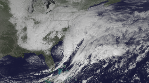
The National Oceanic and Atmospheric Administration is up with a pulled-back perspective on the nor-easter getting ready to dump massive amounts of snow on the northeast.
As the image (above), taken with their GOES satellite, suggests, it’s what they call a “doozy.”
Here’s NOAA’s summary of where they expect things to go:
A major winter storm in the process of developing is bringing snow to the Ohio Valley and mid-Atlantic. Blizzard Warnings are in effect for the coastal areas from New Jersey to Maine. A new surface low will develop along the North Carolina/southeast Virginia coast this morning and intensify rapidly as it moves northeastward off the mid-Atlantic coast. From there the storm will move along the northeast coastline from Monday night into Tuesday bringing a significant amount of snow and blustery winds across the northeast and New England causing blizzard conditions. Snow totals of 1 to 3 feet will occur from the New York City area into southern and eastern New England.
Here are the expected snow accumulations for Boston:

And New York:

And here, via the National Weather Service’s Weather Prediction Center, are your odds of seeing more than 18 inches over the next couple of days:

[embedtweet id=”559720252628819969″]
Consider yourself warned.
